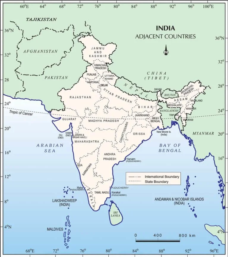
India stands as the world's seventh-largest country by land area and currently holds the position of the most populous nation globally. Geographically situated in Southern Asia, spanning both the Northern and Eastern Hemispheres, India shares robust geographical, political, and cultural connections with its surrounding regions. For aspirants preparing for competitive examinations, mastering static general knowledge regarding India's international borders, coastline measurements, and adjacent sovereign nations is critical.
In total, India shares international borders with nine distinct countries. This comprehensive guide outlines the land and sea boundaries, capital cities, bordering states, and essential national facts for each neighbouring nation.
Overview of India's Borders and Coastline
Understanding the sheer scale of India's perimeter requires looking at both its terrestrial boundaries and extensive maritime coastlines. The data below encapsulates these overarching metrics:
Metric
Details
Article Name
India'Afghanistans Neighboring Countries
Total Neighbouring Countries Of India
9
Neighbouring Countries Of India
Afghanisthan, Pakistan, China, Nepal, Bhutan, Bangladesh, Sri Lanka, Maldives and MyanmarTotal
Total Land Border Of India
15,106.7 k.m.
Toatal Length Of Indian Coastline
7516.6 km
Covers
Neighboring Countries Static Gk
Exams Covered
All exams
Source
Government of India Website
Neighbouring Countries: Capital, Border Length & Bordering States
India shares land borders with seven nations and sea borders with two island nations. The following table details the specific administrative and geographical data for each:
Country
Capital
Border Length
Bordering States
Afghanistan
Kabul
106 Km
Ladakh (PoK)
Bangladesh
Dhaka
4096.7 Km
West Bengal, Meghalaya, Mizoram, Tripura and Assam
Bhutan
Thimphu
699 Km
West Bengal, Sikkim, Arunachal Pradesh & Assam
China
Beijing
3488 Km
Ladakh, Himachal Pradesh, Uttarakhand, Sikkim and Arunachal Pradesh
Myanmar
Naypyidaw, Yangon
1643 Km
Arunachal Pradesh, Nagaland, Mizoram and Manipur
Nepal
Kathmandu
1751 Km
Bihar, Uttarakhand, UP, Sikkim and West Bengal
Pakistan
Islamabad
3323 Km
Jammu and Kashmir, Ladakh, Punjab, Rajasthan and Gujarat
Sri Lanka
Colombo (Commercial), Sri Jayawardenepura Kotte (Legislative)
Sea Border
It is separated to India by Gulf of Mannar
Maldives
Male
Sea Border
It lies in the south-west part of India Ocean below the Lakshadweep Island
In-Depth Static GK Facts for Each Country
Competitive exams frequently test specific national identifiers such as currencies, national games, key leadership figures, and geographical extremes. Below are the comprehensive profiles for each of India's nine neighbours.
Sri Lanka
Some Important Fact About Sri Lanka
President
Gotabaya Rajapaksa
Prime Minister
Mahindra Rajapaksa
Chief Justice
Jayantha Jayasuriya
Official languages
Sinhala, Tamil
State/ Provinces
9 states
Capital and largest city
Sri Jayawardenepura Kotte
Currency
Sri Lankan Rupee (LKR)
National Game
Volleyball
National Bird
Ceylon (Jungle Fowl)
National Fruit
Jackfruit
National Tree
Ironwood
National Flower
Bluewater Lily
Highest peak
Pidurutalagala
Longest river
Mahaweli
Religion
70.2% Buddhism, 12.6% Hinduism
Parliament
Parliamenthua (225 seats)
Famous festivals
Sinhala and Tamil New Year, Vesak, Poson Festival, Kandy Esala Perahera, Kataragama Festival, Vel Festival, Deepavali
China
Some Important Fact About China
President
Xi Jinping
Official languages
Mandarin
State/ Provinces
26 Provinces
Capital
Beijing
Currency
Chinese Yuan (CNY)
National Game
Table Tennis
National Bird
Red-crowned crane
National Fruit
Kiwifruit
National Tree
Maidenhair Tree
National Flower
Plum Blossom (Prunus mei)
National animal
Giant Panda
Longest river
Yangtze River
Boundaries
Jammu and Kashmir, Himachal Pradesh, Sikkim, Uttarakhand and Arunachal Pradesh
Parliament
National Assembly (2980 members)
Border
McMahon Line
Myanmar
Some Important Fact About Myanmar
President
Win Myint
Prime Minister
Aung San Suu Kyi
National anthem
Kaba Ma Kyei
Official languages
Burmese
National animal
Tiger
Capital and largest city
Naypyidaw
Currency
Burmese Kyat
National Game
Chinlone (Caneball)
National Bird
Grey Peacock-Pheasant
National Fruit
Padauk
National Tree
Green Peafowl
Parliament
The House of Representatives (440 seats)
Highest peak
Hkakabo Razi
Longest river
Irrawaddy River
Famous festivals
Thingyan, Kasone, Nayon
Afghanistan
Some Important Fact About Afghanistan
President
Ashraf Ghani
Parliament
Wolesi Jirga (Lower House) (250 members)
Official languages
Dari and Pashto
State/ Provinces
34 Proviences
Capital and largest city
Kabul
Currency
Afghan afghani
National Game
Buzkashi
National Bird
Grey Peacock-the Golden eagle
National Fruit
Prunus persica
National Tree
Afghan Pine
National animal
Snow Leopard
Border
Durand Line
Bhutan
Some Important Fact About Bhutan
Name of king
Druk Gyalpo (Dragon King)
Monarch
Jigme Khesar Namgyel Wangchuck
Prime Minister
Lotay Tshering
Upper house
National Council
Official languages
Dzongkha
State/ Provinces
20 states
Capital and largest city
Thimphu
Currency
Ngultrum (BTN)
National Animal
Takin
National Bird
The Raven
National Game
Archery
National Tree
Cypress(Tsenden)
National Flower
Blue poppy
Religion
77.4% Vajrayana Buddhism, 22.6% Hinduism
Lower house
National Assembly (Tshogdu) 55 seats
Nepal
Some Important Fact About Nepal
President
Bidhya Devi Bhandari
Prime Minister
KP Sharma Oli
Official languages
Nepali
State/ Provinces
7 Provinces
Capital and largest city
Sri Jayawardenepura Kotte
Currency
Nepalese rupee
National Game
Volleyball
National Bird
Himalayan monal (Lophophorus impejanus)
National Animal
Cow
National Tree
Ficus religiosa
National Flower
Rhododendron
Highest peak
Mount Everest
Longest river
Karnali
Parliament
The National Assembly (275 seats)
Bangladesh
Some Important Fact About Bangladesh
President
Abdul Hamid
Prime Minister
Sheikh Hasina
Official languages
Bengali
State/ Provinces
8 Provinces
Capital
Dhaka
Currency
Bangladeshi taka
National Game
Volleyball
National Bird
Oriental Magpie-Robin
National Fruit
Jackfruit(kathal)
National Tree
Mango Tree
National animal
Royal Bengal tiger
Highest peak
Keokradong
Longest river
Surma
Religion
70.2% Buddhism, 12.6% Hinduism
Parliament
Jatiyo Shangsad (Bengali) and House of the Nation(English) (350 Member)
Border
Radcliffe Line
Pakistan
Some Important Facts About Pakistan
President
Arif Alvi
Prime Minister
Imran Khan
Official languages
Urdu, English
State/ Provinces
4 Provinces
Capital
Islamabad
Currency
Pakistani Rupee
National Game
Field Hockey
National Bird
Chukar partridge
National Fruit
Mango(Summer), Guava (Winter)
National Tree
Deodar
National Anthem
Quami Taranah
Highest peak
K2
Longest river
Indus River
Religion
Islam
Parliament
National Assembly (342 seats)
Border
Radcliffe Line
Maldives
Some Important Fact About Maldives
President
Ibrahim Mohamed Solih
Parliament
People's Majlis
Official languages
Dhivehi
State/ Provinces
1 Only
Capital and largest city
Male
Currency
Maldivian Rufiyaa
National Game
Football
National Bird
White-breasted Waterhen
National Fruit
Coconut
National Tree
Coconut Tree
National animal
Yellowfin Tuna
Next Steps for Exam Aspirants
After reviewing these facts and static GK figures, candidates should practice previous years' questions regarding boundary demarcation lines (such as the Radcliffe Line, McMahon Line, and Durand Line). Ensure you regularly revise state mappings and capitals to solidify your preparation for upcoming tests.
Frequently Asked Questions (FAQs)
Ans. India shares borders with 9 neighbouring countries.
Ans. Bangladesh shares the longest land boundary with India.
Ans. Afghanistan shares the shortest land boundary with India.
Ans. China shares a border with 5 Indian states and union territories.
Ans. Bangladesh shares a border with 5 Indian states.