India is home to the second-largest road network globally, serving as the economic circulatory system of the nation. Operating at the core of this massive transport grid are the country's national highways. Though they account for only 1.8% of India's total road length, they facilitate a staggering 40% of the nation's total road traffic. Understanding how these vital corridors are classified, managed, and distributed reveals the intricate web connecting remote regions to bustling metropolitan hubs.
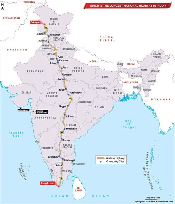
Image source attribution: Maps of India
Overview of India's Highway Infrastructure and Management
As of 2019, India's overall highway network expanded to approximately 142,126 km. Within this vast infrastructure, the combined length of over 200 national highways spans 101,011 km, complemented by 131,899 km of state highways. The development, construction, and ongoing management duties of these corridors are shared collaboratively by the National Highways Authority of India (National Highways Authority of India / NHAI), the National Highways and Infrastructure Development Corporation (NHIDCL), and various state Public Works Departments (PWDs).
To maintain navigation clarity across the country, highway numbering and color codes are strictly regulated:
Understanding Highway Color Coding
- Yellow and white markers denote national highways.
- Green and white markers denote state highways.
- Black and white markers denote city highways.
Furthermore, numbering conventions use 2-digit numbers for main national highways, while 3-digit numbered highways serve as branches or spurs. For instance, Highway 144 acts as a secondary branch of NH 44, and specific secondary routes use alphabetical suffixes like 144A or 244A.
Top Longest National Highways In India
Spanning across diverse topographies—from northern mountain ranges to southern coastal plains—the longest national highways tie the country together. Notably, NH 44 is officially recognized as the longest National Highway in India, measuring 3,745 km and stretching from Srinagar all the way down to Kanyakumari. This vital spine was formed by integrating several historic highways, including NH 1A, NH 1, NH 2, NH 3, NH 75, NH 26, and its former name, NH 7.
Another crucial project is the Golden Quadrilateral (GQ), which links the major economic hubs of Delhi, Kolkata, Mumbai, and Chennai. Additionally, the famous Leh-Manali Highway connects Shimla in Himachal Pradesh to Leh in Ladakh, earning recognition as the second highest-altitude motorable road globally.
Top Longest National Highways Checklist & Data
- 1. NH 44 (old NH 7) - 3,745 km - Srinagar to Kanyakumari
- 2. NH 27 - 3,507 km - Porbandar in Gujarat to Silchar in Assam
- 3. NH 48 (old NH 8) - 2,807 km - Delhi to Chennai
- 4. NH 52 - 2,317 km - Sangrur, Punjab to Ankola, Karnataka
- 5. NH 30 (Old NH 221) - 2,040 km - Sitarganj in Uttarakhand to Ibrahimpatnam in Andhra Pradesh
- 6. NH 6 - 1,873 km - Jorabat in Meghalaya to Selling in Mizoram
- 7. NH 53 - 1,781 km - Hajira in Gujarat to Pradip port in Odisha
- 8. NH 16 (Old NH 5) - 1,711 km - East coast of West Bengal to Chennai in Tamil Nadu
- 9. NH 66 (Old NH 17) - 1,622 km - Panvel to Kanyakumari
- 10. NH 19 (Old NH 20) - 1,435 km - Delhi to Kolkata
- 11. NH 34 - 1,426 km - Gangotri Dham in Uttarakhand to Lakhnadon in Madhya Pradesh
| S. No | National Highway | Distance (in km) | Route |
|---|---|---|---|
| 1 | NH 44 (old NH 7) | 3,745 | Srinagar to Kanyakumari |
| 2 | NH 27 | 3,507 | Porbandar in Gujarat to Silchar in Assam |
| 3 | NH 48 (old NH 8) | 2,807 | Delhi to Chennai |
| 4 | NH 52 | 2,317 | Sangrur, Punjab to Ankola, Karnataka |
| 5 | NH 30 (Old NH 221) | 2,040 | Sitarganj in Uttarakhand to Ibrahimpatnam in Andhra Pradesh. |
| 6 | NH 6 | 1,873 | Jorabat in Meghalaya and terminates at Selling in Mizoram |
| 7 | NH 53 | 1,781 | Hajira in Gujarat and Pradip port in Odisha. |
| 8 | NH 16 (Old NH 5) | 1,711 | East coast of West Bengal to Chennai in Tamil Nadu. |
| 9 | NH 66 (Old NH 17) | 1,622 | Panvel and terminates at Kanyakumari |
| 10 | NH 19 (Old NH 20) | 1,435 | Delhi to Kolkata |
| 11 | NH 34 | 1,426 | Gangotri Dham in Uttarakhand to Lakhnadon in Madhya Pradesh |
Shortest National Highways in India
While cross-country corridors command headlines, short-distance national highways play critical localized roles. NH 118 and NH 548 share the title of the shortest national highways in India, each measuring approximately 5 km in length. NH 118 efficiently connects Asanbani to Jamshedpur in Jharkhand, while NH 548 is situated within Maharashtra, providing targeted connectivity for regional logistics and commuter transit.
Travel Preparation & Next Steps
When planning long-distance travel across India's extensive highway grid, drivers should check route conditions, verify toll plazas, review vehicle documentation, and prepare for varied climatic terrains, particularly when traversing high-altitude routes like the Leh-Manali Highway.
Frequently Asked Questions (FAQs)
Recommended Reads
- Top 10 Longest Rivers in the World: Comprehensive Geographic Overview
- Top 10 Longest Bridges in India: Length, Locations & Key Facts
- Top 10 Longest Rivers in India: A Comprehensive Geographical Guide
- CIL MT Answer Key 2026: CBT Exam Solution PDF & Download Link
- Federal Bank Sales Officer Recruitment 2026: Apply Online for Corporate Salary Posts
- ADA Recruitment 2026: Apply for 111 Project Assistant Posts (ADV-139)
Exam Photo & Signature Resizer (20KB - 50KB)
Resize passport photo & signature to 20-50KB with Name & Date of Photo (DOP) strip or combine them in 1-click.
Never miss another exam update!
Get the fastest exam results, recruitment news, and educational guides delivered directly to your phone.